 Covering COVID-19 is a daily Poynter briefing of story ideas about the coronavirus and other timely topics for journalists, written by senior faculty Al Tompkins. Sign up here to have it delivered to your inbox every weekday morning.
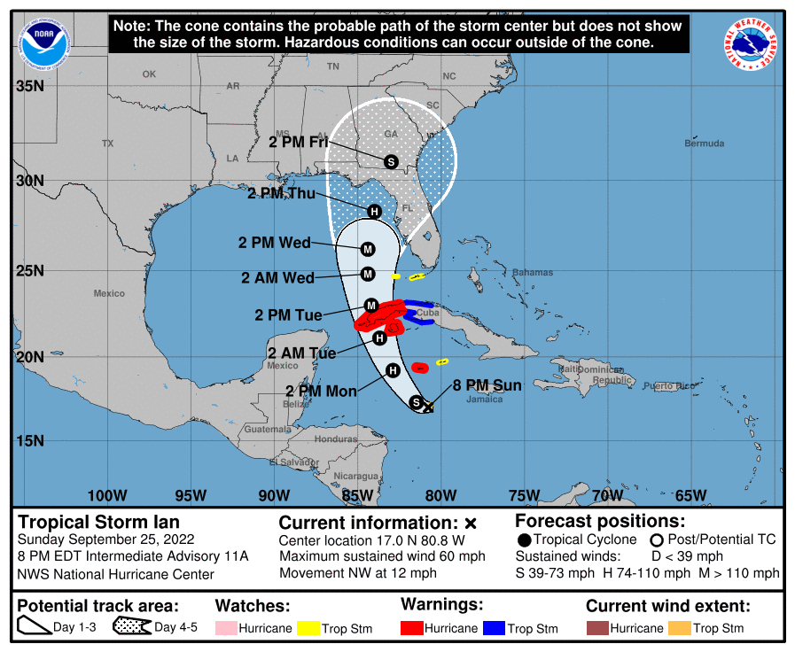
The National Hurricane Center’s forecast cones are not what some people think they are.
The cone is the best guess of where the center of the storm will land. That is why it is unwise to focus on the center of the cone. The cone is not the forecast. It is, in effect, the average of errors.
The average error for day five of the cone is around 200 miles. That is why forecasters tell us to pay attention to the entire cone. A third of the time, the center of the hurricane is not even in the initial cone by day five.
The National Hurricane Center says it “builds the cone by formed by enclosing the area swept out by a set of circles along the forecast track (at 12, 24, 36 hours, etc.).” Those circles are the designations that you see on the tracking line. The National Hurricane Center explains:
One can also examine historical tracks to determine how often the entire 5-day path of a cyclone remains completely within the area of the cone. This is a different perspective that ignores most timing errors. For example, a storm moving very slowly but in the expected direction would still be within the area of the cone, even though the track forecast error could be very large. Based on forecasts over the previous 5 years, the entire track of the tropical cyclone can be expected to remain within the cone roughly 60-70% of the time.
The size of the cone is not an indication of how strong a storm will become.
The National Hurricane Center updates its forecast track at 5 a.m., 11 a.m., 5 p.m. and 11 p.m.
While the cone is sometimes called the “cone of uncertainty,” hurricane tracking has become extremely accurate. But like any weather forecast, the further out you are forecasting, the less accurate it will be because so many factors have to be considered.
Don’t forget Puerto Rico
It may be human nature to worry about the emergency ahead and forget the one that happened a week ago. The people of Puerto Rico are still reeling from Hurricane Fiona. Almost half of the island’s population does not have electricity and one in five residents does not have water service.
Canadians take a hit from Fiona
I want to be sure we do not breeze by the damage done to the Canadian Maritimes. It was the strongest tropical storm in Canadian history. The CBC reports:
Communities in southwestern Newfoundland are grappling with significant damage, including lost homes, flooding and road washouts due to post-tropical storm Fiona.
Everything east of town hall in Port aux Basques is under an emergency evacuation order as the town is pounded by severe winds and storm surge.
“What’s actually happening here is total devastation,” said Mayor Brian Button.
Why warmer oceans mean more powerful hurricanes
NASA reminds us, “21 percent more storms form for every 1.8 degrees Fahrenheit (1 degree Celsius) that ocean surface temperatures rise. … ‘It is somewhat common sense that severe storms will increase in a warmer environment.’”
NASA’s research shows, “Extreme storms — those producing at least 0.12 inches (3 millimeters) of rain per hour over a 16-mile (25-kilometer) area — formed when the sea surface temperature was higher than about 82 degrees Fahrenheit (28 degrees Celsius).”
And sea temperatures have been rising globally:
Here are “real-time” water temperatures in the Gulf of Mexico, which will affect the current system entering the gulf.
Water temperature does not, by itself, determine how strong a storm will become, it is a factor. The WeatherOps blog explains, “For intensification to occur, water temperatures generally need to be at least 80°F (27°C). Hurricanes can be thought of as large heat engines; as the warm ocean water evaporates into a system, latent heat is released. The warmer the water is, the more latent heat is released. This latent heat is what causes the system to intensify. To some extent, winds can also play a role; stronger winds are more efficient in transporting this heat throughout the storm.”
Understanding storm surge
Storm surge is the other factor, besides wind, that people in the path of a hurricane fear. Storm surge is not the same as the flooding that happens when sewer systems get overrun by heavy rain.
The National Oceanic and Atmospheric Administration reminds us, “storm surge is often the greatest threat to life and property from a hurricane. In the past, large death tolls have resulted from the rise of the ocean associated with many of the major hurricanes that have made landfall. Hurricane Katrina (2005) is a prime example of the damage and devastation that can be caused by surge. At least 1500 persons lost their lives during Katrina and many of those deaths occurred directly, or indirectly, as a result of storm surge.”
NOAA says, “Storm surge is an abnormal rise of water generated by a storm, over and above the predicted astronomical tides. Storm surge should not be confused with storm tide, which is defined as the water level rise due to the combination of storm surge and the astronomical tide. This rise in water level can cause extreme flooding in coastal areas particularly when storm surge coincides with normal high tide, resulting in storm tides reaching up to 20 feet or more in some cases.”
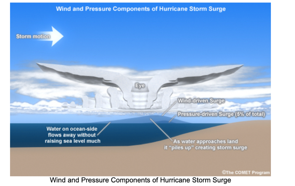
So how does storm surge happen? NOAA says, “Storm surge is produced by water being pushed toward the shore by the force of the winds moving cyclonically around the storm. The impact on surge of the low pressure associated with intense storms is minimal in comparison to the water being forced toward the shore by the wind.”
Think of it like this: Imagine you stick your hand in the center of a bathtub full of water and swirl it around. The faster you swirl, the more wave action, or surge, you will see around the edge of the tub. The damage from a hurricane is not just from the wind above the surface; it can be caused by the push of the water onto land.
Some surge vulnerability facts from NOAA:
- From 1990-2008, population density increased by 32% in Gulf coastal counties, 17% in Atlantic coastal counties, and 16% in Hawaii (U.S. Census Bureau 2010)
- Much of the United States’ densely populated Atlantic and Gulf Coast coastlines lie less than 10 feet above mean sea level
- Over half of the Nation’s economic productivity is located within coastal zones
- 72% of ports, 27% of major roads, and 9% of rail lines within the Gulf Coast region are at or below 4 ft elevation
- A storm surge of 23 ft has the ability to inundate 67% of interstates, 57% of arterials, almost half of rail miles, 29 airports, and virtually all ports in the Gulf Coast area
Here are some historic storm surge events from NOAA:
- Ike 2008 (SLOSH Historical Run): Hurricane Ike made landfall near the north end of Galveston Island as a Category 2 hurricane. Storm surges of 15-20 feet above normal tide levels occurred along the Bolivar Peninsula of Texas and in much of the Galveston Bay area. Property damage from Ike is estimated at $24.9 billion. More…
- Katrina 2005 (SLOSH Historical Run): Katrina was one of the most devastating hurricanes in the history of the United States. It produced catastrophic damage – estimated at $75 billion in the New Orleans area and along the Mississippi coast – and is the costliest U. S. hurricane on record. Storm surge flooding of 25 to 28 feet above normal tide levels was associated with Katrina. More…
- Dennis 2005 (SLOSH Historical Run): Dennis affected much of Florida, and its effects extended well inland over portions of the southeastern United States with the maximum amount rainfall of 12.80 inches occurring near Camden, Alabama. Storm surge flooding of 7-9 ft produced considerable storm surge-related damage near St. Marks, Florida, well to the east of the landfall location. The damage associated with Dennis in the United States is estimated at $2.23 billion. More…
- Isabel 2003 (SLOSH Historical Run): Isabel was the worst hurricane to affect the Chesapeake Bay region since 1933. Storm surge values of more than 8 feet flooded rivers that flowed into the bay across Virginia, Maryland, Delaware, and Washington, D.C. Isabel was the most intense hurricane of the 2003 season and directly resulted in 17 deaths and more than $3 billion in damages. More…
- Opal 1995 (SLOSH Historical Run): Hurricane Opal made landfall near Pensacola Beach, Florida as a Category 3 hurricane. The storm caused extensive storm surge damage from Pensacola Beach to Mexico Beach (a span of 120 miles) with a maximum storm tide of 24 feet, recorded near Fort Walton Beach. Damage estimates for Opal were near $3 billion. More…
- Hugo 1989 (SLOSH Historical Run): Hugo impacted the southeastern United States, including South Carolina cities Charleston and Myrtle Beach. Hugo was responsible for 60 deaths and $7 billion in damages, with the highest storm surge estimated at 19.8 feet at Romain Retreat, South Carolina. More…
- Camille 1969 (SLOSH Historical Run): Camille was a Category 5 hurricane, the most powerful on the Saffir-Simpson Hurricane Wind Scale with maximum winds of more than 155 mph and storm surge flooding of 24 feet that devastated the Mississippi coast. The final death count for the U.S. is listed at 256. This includes 143 on the Gulf coast and another 113 from the Virginia floods. More…
- Audrey 1957 (SLOSH Historical Run): There were 390 deaths associated with Audrey as the result of a storm surge in excess of 12 feet, which inundated the flat coast of southwestern Louisiana as far as 25 miles inland in some places. More…
- New England 1938 (SLOSH Historical Run): The Long Island Express was a fast-moving Category 3 hurricane that struck Long Island and New England with little warning on September 21. A storm surge of 10 to 12 ft inundated the coasts of Rhode Island, Connecticut, southeastern Massachusetts, and Long Island, NY, especially in Narragansett Bay and Buzzards Bay. Six hundred people died due to the storm. More…
- Galveston 1900 (SLOSH Historical Run): At least 8,000 people died when hurricane storm tides (the surge plus the astronomical tide) of 8-15 feet inundated most of the island city of Galveston, TX and adjacent areas on the mainland. More…
The Chris Wallace sing-along with Shania Twain
Chris Wallace’s new show debuted on CNN Sunday night. Is this the clip that will endure? Oh, and he interviewed former Supreme Court Justice Stephen Breyer, but there was no singing in that segment.
We’ll be back tomorrow with a new edition of Covering COVID-19. Are you subscribed? Sign up here to get it delivered right to your inbox.


